
Waitahanui River
|
The Waitahanui River is a popular river that while heavily fished in the lower reaches still manages to provide good catch rates for anglers. It also offers 8 km of top quality fishing in a beautiful tranquil setting. |
| Fish type | Brown and rainbow are both present though rainbows make up the bulk of the anglers catch. Fish average around 2kg (4.5lbs) but many much larger fish are caught especially in the winter migratory runs. | |
| Situation | The Waitahanui is an eastern tributary of Lake Taupo which enters the lake 11 kilometres south of Taupo township. It rises from springs at the northern end of the Kaimanawa Forest Park and flows westward until it enters Lake Taupo. | |
| Maps | ||
| Check conditions |
View the MetService weather forecast. |
|
| Description |
The Waitahanui is a beautiful little river that runs between well vegetated banks. While the section near the mouth can get very crowded, the upper reaches offer the chance for anglers to get away from the crowds and fish in solitude in a beautiful tranquil setting. River flow As it is spring fed, the Waitahanui has less fluctuations in flow than other Taupo tributaries and so the riverbed of rock, stone and fine pumice tends to be more stable than some of the bigger rivers such as the Tauranga-Taupo or Tongariro. Although the river is small (mostly between 3 -4 metres wide) it has a surprisingly strong flow so care is still required when crossing or wading. Water quality As this is primarily a spring fed river, the water tends to remain clear and clean even when other rivers in the catchment have flooded and become unfishable. It seldom discolours even after heavy rain meaning it remains fishable for most of the year. Even in the height of summer, the water is very cold providing ideal trout habitat. |
|
| At the mouth |
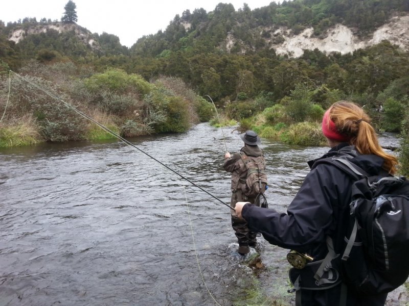
Description Possibly the most photographed part of the Taupo fishery if not of New Zealand is the "picket fence" at the mouth of the Waitahanui where it enters the lake. The picket Methods This famous and often crowded fishing spot suits experienced anglers. It requires a long cast with a floating or intermediate line and a reasonable degree of skill and accuracy When to fish The mouth of the Waitahanui fishes throughout the year with the early morning and late evening through into dark being the best times of the day. Trophy brown trout can be Wind conditions The rip is best fished after a strong westerly or south-westerly when the wind has caused the outflow or rip from the river to run close to the shore. Trout tend to move into the rip to feed and when it is flowing directly out into the lake most fish can only be reached by wading deep and then long casts. After a westerly storm, the current is forced along the beach and 200 metres of the rip can then be fished without wading thus providing less disturbance to the fish which will often come into very shallow water to feed. Access Access to the mouth is from a walking track off SH1 north of Waitahanui Bridge. There are car parks on either side of the State Highway 1 bridge which is about 300 metres from the mouth of the river. This section can be easily fished from either bank as tracks run alongside the river. See the access map. |
|
| Lower reaches
|
The lower reaches of the Waimarina extend from the State Highway 1 Bridge to the mouth. Description Fishing pressure is intense in the lower reaches especially after fresh-run fish have entered the river. The Bridge Pool has changed dramatically over the past few years and now is less of a holding water causing the fish to move upstream. Methods While fish can be spotted in the clear water, most fish are caught fishing blind as they lie deep in the pools or under the overhanging vegetation. Access From SH1 either side of the main road bridge. There are carparks on either sides of the bridge and walking tracks provide good access to all parts of this section. See the access map. Delatours Pool - Upstream from the Bridge Pool is Delatours pool where the Mangamutu tributary enters the Waitahanui. |
|
| Middle and upper reaches
|
The middle and upper reaches extend from SH1 to the upper winter fishing limit. Description The middle and upper reaches provide some delightful stretches of water in tranquil surroundings with fewer fellow anglers. The river bed is generally clear and unobstructed though large fish can make life difficult for the angler by heading for the nearest vegetation where they will hook any trailing fly, or by heading downstream at speed where the bankside vegetation can make any hope of following them almost impossible. Pools Although swiftly flowing in parts, there are some excellent deep holding pools that are relatively easy to fish. Other pools are more difficult due to vegetation on the river bank Some of the pools are named (Totara Bridge and The Pig are just some of the more popular and well known pools in this section) but the fishing of individual pools is less important than on other rivers such as the Tongariro. Most anglers prefer to walk, fishing pools and runs as they move. Take care when wading as some runs are swift and deep. Access The reaches above the SH1 bridge are easily accessed along well defined and maintained walking tracks. Note that many tracks take a direct route through Maori land and you need to be aware of access rights and issues (see "Access rights and issues" below). Middle reaches: From SH1, follow Mill Road to the carpark at the end of the road. Upper reaches: On SH1 south of the Waitahanui Bridge, turn into Blake Road. The road is closed at the Totara Bridge turn-off which means that the upper reaches are only accessible by those prepared to walk. There are excellent walking tracks along both banks of the river and several picturesque arched bridges cross the river at various points allowing excellent access to a wide variety of fishable water. See the access map. |
|
| Headwaters |
Description: The headwaters are deep, overgrown and very difficult if not impossible in places to fish. Access: You need to obtain permission from the Forestry Corporation to use the forestry roads behind Iwitahi on SH5. |
|
| Access rights and issues |
Many tracks take a direct route through Maori land. The public is entitled to free foot access through the Wharekawa Scenic Reserve which follows the true left bank of the river from the SH1 bridge up to Butler's Bend. The rest of the river has a 20 metre wide right-of-way on both banks for licensed anglers travelling on foot. However some local Maori dispute the legality of this agreement. DOC advise that any threats over access be reported to the police. |
|
| Fish numbers and size | Large rainbows and browns are present though most large fish are caught during the winter spawning runs. There are smaller numbers of resident fish that can be targeted during the warmer months. | |